626-298-7198
Wildfires can tear through neighborhoods with alarming speed and unpredictability, especially in areas known as the wildland-urban interface (WUI), where homes meet undeveloped vegetation. Here’s how the process typically unfolds:
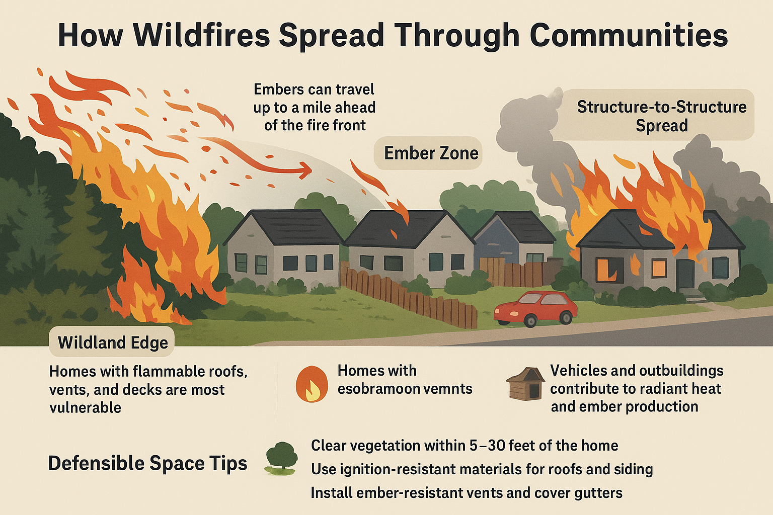
🔥 Key Mechanisms of Wildfire Spread in Neighborhoods
- Ember Attacks (Spot Fires):
- Burning embers can travel miles ahead of the main fire front, carried by wind.
- Embers land in landscaping and crawl across yards as the heat dries out green vegetation and ignites it creating more traveling embers.
- These embers land on flammable landscaping, rooftops, in gutters, or near igniting new fires far from the original blaze.
- Radiant Heat:
- Intense heat from nearby flames can ignite structures without direct contact.
- Homes close together are especially vulnerable, as one burning house can radiate enough heat to ignite its neighbor.
- Direct Flame Contact:
- If vegetation or flammable materials are close to a home, flames can directly reach and ignite the structure.
- Wooden fences, decks, and mulch are common ignition points.
- Hopscotch Spread:
- Fires often leap from one structure to another in a “hopscotch” pattern, bypassing some homes while destroying others.
- This pattern depends on wind direction, fuel availability, and building materials.
🏡 Factors That Influence Fire Behavior in Neighborhoods
- Construction Materials:
- Homes built with fire-resistant materials (e.g., metal roofs, stucco siding) are less likely to ignite.
- Landscaping and Vegetation:
- Dense vegetation, dry brush, and flammable landscaping increase risk.
- Defensible space—cleared zones around homes—can slow fire spread.
- Neighborhood Layout:
- Densely packed homes allow fire to spread more easily.
- Isolated homes may be more vulnerable to ember attacks but less likely to ignite neighboring structures.
- Topography and Wind:
- Fires move faster uphill and with the wind.
- Neighborhoods on slopes or in wind corridors face higher risk.
Researchers are now using advanced models to simulate these dynamics, helping communities better understand and mitigate wildfire risks.
Leave a Reply